As two fast-moving Alberta Clippers sweep across southern Ontario, Waterloo Region is grappling with hazardous winter weather conditions that have already disrupted commutes, closed roads, and prompted official warnings. Environment Canada has issued a yellow warning for snowfall, cautioning residents about the potential for 10 to 20 centimetres of snow, blowing winds, and rapidly deteriorating travel conditions through Wednesday and into Thursday.
The series of low-pressure systems hammered the region with a mix of snow and freezing rain Tuesday afternoon before transitioning into heavier, blowing snow early Wednesday morning. Forecasters continue to warn that the storm’s impact may linger, especially with lake-effect snow in the outlook.
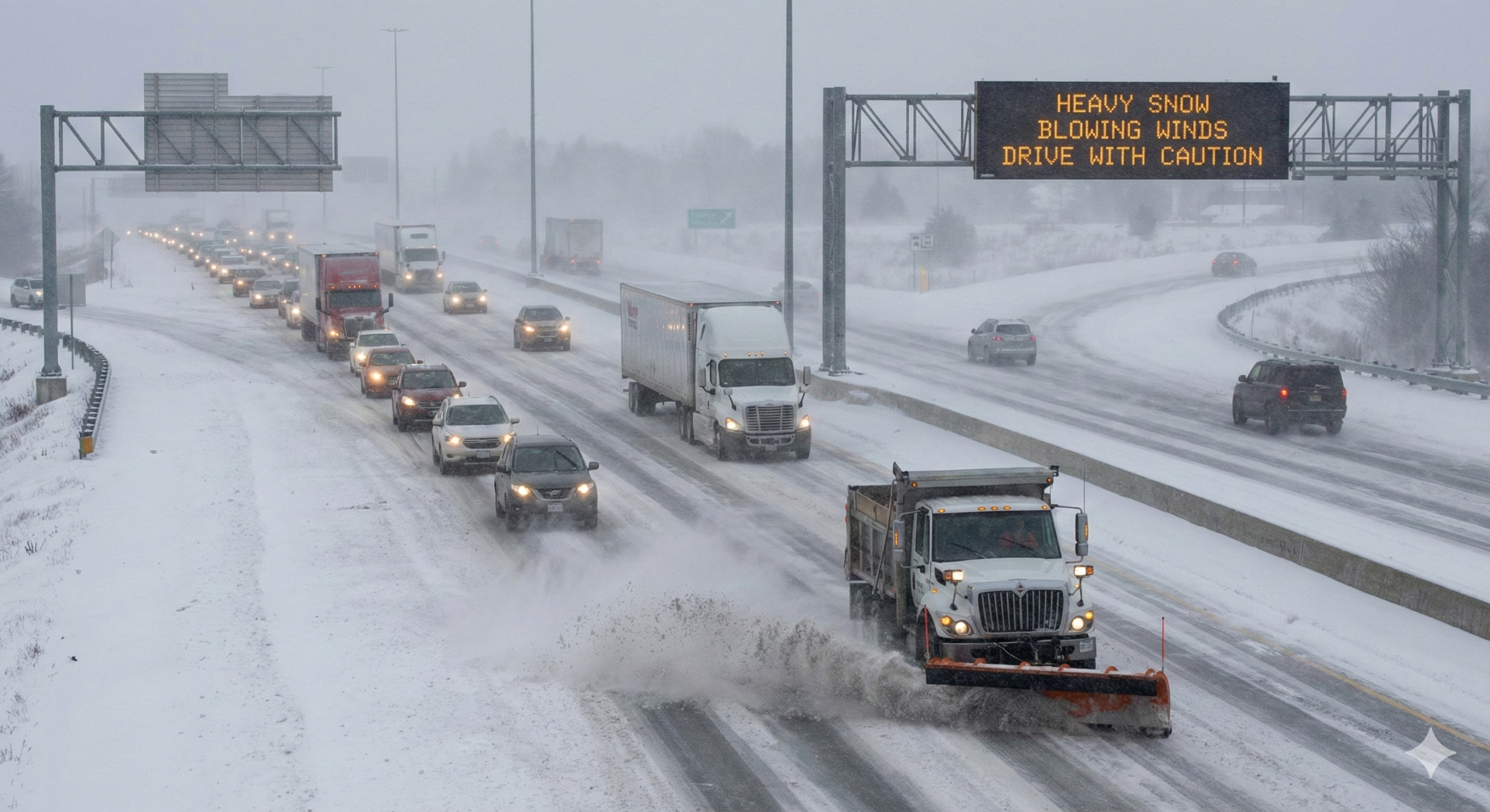
A Midweek Commute Marked by Hazardous Conditions
Heavy Snowfall and Poor Visibility
Waterloo Region woke up Wednesday morning to intense snow flurries and reduced visibility as the second of two Alberta Clippers swept through. By 8 a.m., parts of Kitchener had already recorded 6 centimetres of accumulation, with significantly more expected throughout the day.
Environment Canada noted that blowing snow, coupled with strong winds, is contributing to treacherous driving conditions on major routes and rural roads. The agency emphasized that travel could be “challenging at times,” urging motorists to slow down, maintain safe distances, and prepare for sudden changes in visibility.
Snow Events Declared Across the Region
With accumulating snowfall expected throughout Wednesday and Thursday, the cities of Kitchener, Cambridge, and Waterloo announced that snow events are officially in effect. These declarations typically require residents to remove vehicles from designated roadways to allow snowplows to operate efficiently and ensure road safety during significant snowfall.
Municipal crews began early operations to manage the storm, but the severity of the weather means streets may remain snow-covered for extended periods.
Road Closures and Crashes Plague the Region
Numerous Vehicles in Ditches Overnight
Between Tuesday afternoon and Wednesday morning, authorities received multiple reports of vehicles sliding into ditches across the region. Freezing rain on Tuesday created slick roadways that quickly transitioned into snow-covered surfaces as temperatures fell, prompting widespread driving difficulties.
Emergency responders were kept busy throughout the evening and into the early morning hours as motorists struggled with loss of traction, whiteout conditions, and icy intersections.
Highway 401 Closure at Drumbo and Ayr
One of the most significant disruptions occurred along Highway 401, where the eastbound lanes were fully closed in the Drumbo and Ayr area due to a weather-related crash. The closure caused major traffic delays and forced many drivers to seek alternate routes as crews worked to clear the scene and improve road conditions.
Multi-Vehicle Crash North of Waterloo
In another serious incident, Waterloo Regional Police reported a major closure on Line 86 west of Elmira following a multi-vehicle collision. Police advised drivers to avoid the area entirely while first responders and cleanup crews worked to manage the aftermath of the crash.
Authorities noted that the combination of blowing snow and rapidly accumulating drifts made rural roads particularly dangerous, with some stretches becoming nearly impassable.
Coldest Temperatures of the Season Ahead
Bitter Arctic Air Expected This Weekend
Following the passage of the two Alberta Clippers, Waterloo Region is expected to experience the coldest air mass of the season. Forecasters predict a sharp drop in temperatures beginning Sunday, with the mercury falling steadily throughout the day.
By around noon, temperatures are expected to reach -9°C, dropping further to approximately -14°C by Sunday evening. Wind chill values may make it feel even colder, especially during the early morning and overnight hours.
Environment Canada urges residents to prepare for the cold snap by dressing in layers, avoiding prolonged exposure to frigid winds, and ensuring vehicles are winter-ready.
Lake-Effect Snow to Continue Into Thursday
Lingering Flurries and Squalls Expected
Even after the main weather systems pass through, the region will continue to see lake-effect snow — a common occurrence when cold Arctic air flows over the warmer waters of the Great Lakes. This pattern often produces localized but intense snow squalls that can develop rapidly and significantly reduce visibility within minutes.
Forecasters warn that additional snowfall could accumulate in pockets, creating variable conditions from one neighbourhood to the next. Roads may clear in one area only to become heavily snow-covered a few kilometres away.
Motorists are advised to remain cautious, especially during evening commutes and early morning hours when roads may refreeze or new squalls develop unexpectedly.
Understanding the Alberta Clipper Phenomenon
Fast-Moving Storm Systems That Pack a Punch
An Alberta Clipper is a quick-moving low-pressure system that originates in the province of Alberta before sweeping across the Prairies, the Great Lakes, and parts of eastern Canada during the winter months.
These systems are known for their speed and intensity. While they typically bring light to moderate snowfall, they often produce strong winds, frigid temperatures, and blowing snow, which can significantly worsen travel conditions. Clippers can develop quickly and leave little time for preparation, making them particularly challenging for drivers and road maintenance crews.
Why Clippers Create Such Hazardous Conditions
Unlike slow-moving winter storms that bring heavy mixed precipitation, Alberta Clippers are distinct in how quickly they travel and how aggressively they drop temperatures. Their rapid movement means communities may receive snow, freezing rain, and a temperature drop in a matter of hours.
In this week’s case, the back-to-back clippers created a one-two punch: freezing rain on Tuesday followed by heavy flurries and blowing snow Wednesday, prolonging transit delays and increasing the risk of accidents.
Authorities Encourage Caution as Winter Intensifies
Preparing for Another Challenging Week of Winter
With more snow in the forecast and extreme cold on the horizon, residents are being encouraged to take extra caution during commutes and outdoor activities. Authorities recommend allowing additional travel time, equipping vehicles with winter tires, and avoiding unnecessary travel during active snow squalls.
Snow-clearing operations will continue around the clock, but municipal officials stress that heavy snowfall and blowing winds may still result in temporary road hazards.
As Waterloo Region braces for additional winter challenges over the coming days, the message from officials remains clear: stay alert, stay patient, and stay safe.
Leave a Reply