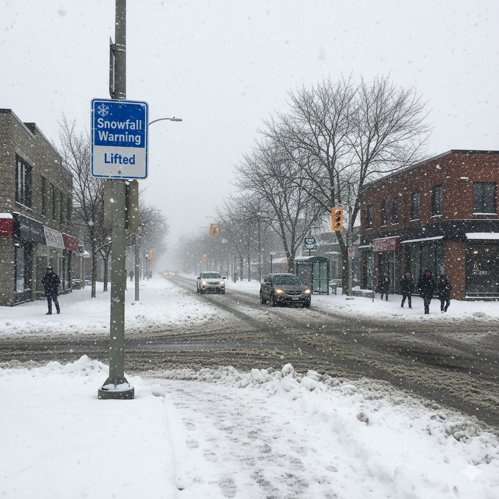
The official snowfall warning issued for Waterloo Region may have expired, but winter conditions are far from easing their grip. Residents woke up Sunday to a landscape still blanketed in fresh snow, with light flurries continuing through much of the day and more accumulation expected before conditions finally begin to stabilize.
Environment Canada confirmed that an additional 10 to 15 centimetres of snow was likely to fall between Saturday night and Sunday, adding to the significant accumulation already received over the weekend. While the heaviest bands of snow have moved on, intermittent flurries — possibly mixed with light rain at times — were forecast to persist into the afternoon hours. Meteorologists also cautioned that snowfall activity could resume again as early as Monday.
Although no further weather advisories remained in place by Sunday morning, roads across the region remained dangerous, with thick snow layers compacted onto major streets and highways, reducing traction and visibility for drivers and pedestrians alike.
Flurries Continue Despite End of Official Warning
Though the snowfall warning had formally ended, Environment Canada maintained that winter weather had not entirely subsided. Light snow, paired occasionally with rain, was expected to fall in bursts throughout the day, creating unpredictable conditions on the roads.
Moisture in the atmosphere, combined with a steady stream of cold air, allowed the snowy pattern to persist. While the intensity was weaker than previous days, even small amounts of snow had the potential to worsen already difficult travel conditions.
Local areas such as New Hamburg reported consistent light snowfall early Sunday morning, indicating that lingering weather activity was still affecting much of the southwestern Ontario corridor.
High Winds Add to Hazardous Driving Conditions
One of the more significant concerns throughout the day was wind. Carl Lam, a meteorologist with 570 News Radio, explained that strong gusts were expected to accompany the snowfall, particularly into the afternoon. Winds from the southwest were expected to build, reaching gusts of up to 60 kilometres per hour.
These winds were forecast to shift direction later in the day as a cold front passed through the region. Once the front arrived, colder air and northwesterly winds would take over, potentially worsening blowing snow and further reducing visibility on already dangerous roadways.
Blowing snow created whiteout-like conditions in some rural areas and along open stretches of highway — especially where snow had drifted onto exposed pavement.
Wind Chill Makes Temperatures Feel Colder
While the daytime high was forecasted to reach around 1°C, the presence of strong winds meant the temperature would feel significantly colder. Lam noted that wind chill values could make outdoor conditions feel closer to -12°C, increasing the risk of frostbite for those exposed to the elements for extended periods.
These colder, wind-driven conditions required residents to take extra precautions when venturing outside, whether commuting, clearing driveways, or helping others dig out from the snowfall.
Municipal Snow Events and Parking Bans Remain in Place
Although the broader weather warning had lifted, several local governments continued to enforce snow events and parking restrictions to allow crews to clear roadways effectively.
The City of Waterloo announced its snow event and parking ban would remain in effect until at least noon on Monday. Similarly, the City of Kitchener extended its parking restrictions through 3 p.m. on Monday to ensure plows and salt trucks could continue operations without obstruction.
These measures were essential in helping municipal workers clear the mountains of snow that built up over the last several days. Residents were reminded that parking on restricted streets could significantly slow down snow-clearing efforts and result in tickets or vehicle relocation.
Municipal officials urged drivers to be patient as crews worked around the clock to restore safe driving and pedestrian conditions.
Heavy Snowfall Over the Weekend Causes Widespread Disruption
The weekend storm that swept through the Waterloo Region delivered astonishing amounts of snow in a short period of time. According to Environment Canada meteorologist Rob Kuhn, approximately 33 centimetres of snow had accumulated in the Stanley Park area of Kitchener by Friday afternoon alone.
That intense burst of snowfall created widespread disruptions across the region, forcing several business closures, school cancellations, and roadway shutdowns. A portion of westbound Highway 401 near Drumbo was shut down due to poor visibility and hazardous driving conditions.
Emergency services responded to numerous incidents, including vehicles stuck in snowbanks, collisions in slippery intersections, and stranded motorists on rural roads. Tow trucks and emergency crews were kept busy throughout the storm.
Impact on Cities and Surrounding Townships
The snowfall did not affect only Kitchener and Waterloo. Surrounding communities including Cambridge, Wilmot, Woolwich, and Wellesley were also hit hard by the storm.
Rural townships experienced drifting snow in open farmland, making secondary roads particularly difficult to navigate. In some areas, plows struggled to keep up as wind repeatedly blew snow back onto recently cleared sections.
Residents in these outer areas were encouraged to avoid unnecessary travel and to check road conditions before heading out. Local authorities advised carrying winter survival kits in vehicles, including blankets, water, flashlights, and emergency supplies.
Potential for More Snow on Monday
Even as cleanup efforts continued, forecasts hinted that winter was not yet finished with the region. Weather models indicated that snow activity may pick up again on Monday, although at lower intensities compared to Friday’s major event.
This potential return of snowfall added urgency to municipal efforts to clear as much snow as possible before the next wave arrived. Public works teams continued operating through the weekend, focusing on major roads, emergency routes, and public transit corridors.
Residents Urged to Stay Informed and Prepared
Officials urged residents to remain cautious over the coming days and to closely monitor weather updates and travel advisories. Conditions could change rapidly, especially with fluctuating temperatures and changing wind directions.
Residents were also reminded to check on neighbours, particularly seniors or those with limited mobility, who may require assistance with snow removal or groceries.
Listening to local radio stations such as 570 News Radio was recommended for the most up-to-date information on traffic, road closures, and evolving weather conditions throughout Waterloo Region and beyond.
Conclusion: Winter’s Grip Still Strong Over Waterloo Region
While the formal snowfall warning may have ended, its impact is still being felt across Waterloo Region. Snow-packed roads, strong winds, and bitter wind chills continue to pose challenges for the community. With more light snow possible and plowing operations ongoing, local residents are being asked for patience, preparedness, and caution.
Leave a Reply